


Benoit Voting District, Bolivar County, Mississippi
About
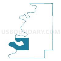
Outline

Summary
| Unique Area Identifier | 605135 |
| Name | Benoit Voting District |
| County | Bolivar County |
| State | Mississippi |
| Area (square miles) | 86.50 |
| Land Area (square miles) | 80.55 |
| Water Area (square miles) | 5.95 |
| % of Land Area | 93.12 |
| % of Water Area | 6.88 |
| Latitude of the Internal Point | 33.64875650 |
| Longtitude of the Internal Point | -91.03094740 |
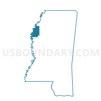
Maps

Graphs
Select a template below for downloading or customizing gragh for Benoit Voting District, Bolivar County, Mississippi


Neighbors
Neighoring Voting District (by Name) Neighboring Voting District on the Map
- Beulah Voting District, Bolivar County, MS
- Franklin Voting District, Desha County, AR
- Longshot Voting District, Bolivar County, MS
- Scott Voting District, Bolivar County, MS
Top 10 Neighboring County Subdivision (by Population) Neighboring County Subdivision on the Map
Top 10 Neighboring Place (by Population) Neighboring Place on the Map
Top 10 Neighboring Unified School District (by Population) Neighboring Unified School District on the Map
- McGehee School District, AR (6,822)
- West Bolivar School District, MS (4,288)
- Benoit School District, MS (1,371)
Top 10 Neighboring State Legislative District Lower Chamber (by Population) Neighboring State Legislative District Lower Chamber on the Map
- State House District 12, AR (22,630)
- State House District 28, MS (20,377)
- State House District 29, MS (18,559)
Top 10 Neighboring State Legislative District Upper Chamber (by Population) Neighboring State Legislative District Upper Chamber on the Map
- State Senate District 23, AR (75,803)
- State Senate District 22, MS (48,806)
- State Senate District 12, MS (43,572)